Full name: Zhuraev Marcifali Turgunbayevich
On the position: Since March 1, 2013
Position: Head of the Laboratory
The laboratory provides the following services:
-
Carrying out continuous environmental monitoring during geological exploration.
-
Development of a draft statement on the impact on the environment (EIA) and environmental protection measures for the conduct of geological exploration.
-
Development of a draft statement about environmental consequences (EC) during geological exploration.
-
Study and assessment of groundwater pollution and development of localization and liquidation systems for groundwater treatment from various polluting ingredients.
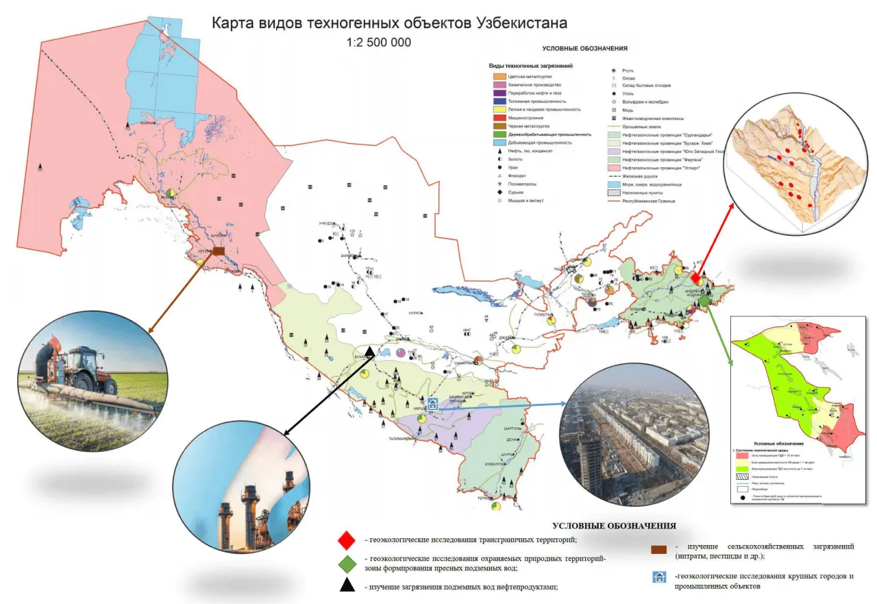
Engaged in the assessment of the current ecological state of the geological environment of the Republic of Uzbekistan under conditions of active anthropogenic impact (the second stage of the international project to compile the Atlas of Maps of Central Eurasia at a scale of 1: 2500000
Previously completed work:
-
1. . Assessment of the current ecological state of the geological environment of the Republic of Uzbekistan under conditions of active anthropogenic impact (the second stage of the international project to compile the Atlas of Maps of Central Eurasia at a scale of 1:2500000)
The map of the technogenic impact on the geological environment and a map for assessing the ecological state and technogenic changes in the geological environment of the Republic of Uzbekistan at a scale of 1: 2500000 were compiled. -
2. Assessment of the current ecological state of the geological environment and compilation of geoecological maps at a scale of 1:1000000 for transboundary territories with the most intense anthropogenic load (Aral and Fergana regions) within the framework of the International Project for Central Eurasia.
A seven-leaf version of the geoecological map of the Aral and Fergana regions was compiled. -
3. Compilation of the Atlas of geoecological maps of the Republic of Uzbekistan. An assessment of the current ecological state of the geological environment was given, geoecological maps of developed territories were compiled at a scale of 1: 200000 and for the Republic of Uzbekistan at a scale of 1:500000.
-
4. Assessment of the geoecological conditions of the dried bottom of the Aral Sea to solve the problem of desertification and environmental protection. An assessment of the ecological state of the dried bottom of the Aral Sea was given and a set of maps at a scale of 1: 500000 of geological and geoecological content was compiled.
-
Laboretory carris out workon geoecological research and mapping to assess the ecological state of the geological environment and justify a set of environmental measures, environmental audit (determination of the current state of the environment) during geological exploration for oil, gas and other minerals.
To date, the following results have been obtained:
-
– established regional geo-ecosystems of Uzbekistan and their characteristic models;
-
– recommendations have been developed to minimize geo-environmental damage and prevent them in the future. A set of auxiliary maps and maps of geo-ecological systems of Uzbekistan has been prepared at a scale of 1: 500000. The results of this work are recommended to be used by organizations and specialists involved in environmental protection and the development of environmental measures
-
– on the basis of this ecological and geological model, a project was developed to assess the impact of the agro-industry on the state of the geological environment of the Ferghana Valley;
-
– an analysis of the current state and an assessment of world and domestic experience in the disposal of polluted waters in deep aquifers was carried out;
-
– the legal framework for the disposal of associated edge and industrial wastewater into aquifers was determined;
-
– dozens of changes in groundwater in the exploited aquifer under the influence of the agro-industrial complex were assessed;
-
– the influence of agro-industrial complexes on the state of the geological environment of the southern and northern parts of the Ferghana Valley was studied and evaluated;
-
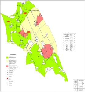
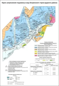
– electronic maps of groundwater pollution in the Angren mining region were compiled at a scale of 1:50000. They were determined for some areas of increased values of mineralization, total hardness and sulfates;
-
– geoecological studies and mapping at a scale of 1:50000 were carried out within the protected natural areas – the formation zones of the Chimion-Auval fresh groundwater deposit and land monitoring in the border regions of Uzbekistan;
-
– geoecological studies were carried out within the protected natural areas – the formation zones of the Osh-Aravan and Narin deposits of fresh groundwater;

-
-
– geoecological studies and mapping of various scales were carried out in specially protected natural areas, areas affected by gold mining enterprises and border areas.
-
– the ecological state of the geological environment of the Aral region was assessed, the development of natural complexes and the processes of salt accumulation in the soils of the dried bottom of the Aral Sea were studied;
-
– hydrogeological studies were carried out within the intercepting line “OASIS” in the area of the FOR in order to optimize the system for monitoring the state of the water in the zone of its influence at the Tashlak site;
-
– efficiency factors of equipment of foreign desalination plants were estimated depending on the type of desalination plant and its features. Possibilities of using the groundwater desalination plant are given. The selection of the most efficient and energy-saving methods of desalination and installations for their implementation was carried out;
-
– electronic maps of groundwater pollution were compiled for the Muruntau section of the Central Kyzylkum mining district on a scale of 1:50000. Weak pollution was determined within the Central Kyzylkum region in the form of several large-sized blue caps;
-
– research work was carried out in the cities of Karshi, Angren, Bukhara, Chirchik, Samarkand, Navoi. For each studied territory, layouts of maps of technogenic load, stability of the geological environment and a map of pollution of the geological environment were compiled. The cities with the most dangerous technogenic load and the degree of influence on the geoecological situation in general were identified;
-
– an ecological and hydrogeological map of the protected area of the Chimion-Auval deposit was compiled on a scale of 1: 50000, and areas with a satisfactory and stressed state of groundwater were identified.
-
– spatial zonality of changes in the chemical composition of groundwater in the Republic of Uzbekistan using GIS technologies was identified;
-
– geoecological studies and mapping at a scale of 1:50000 were carried out within the protected natural areas – the formation zones of the Chimion-Auval fresh groundwater deposit and land monitoring in the border regions of Uzbekistan.
-