Full name: Saidova Sayera Anvarovna
In office: Since March 1, 2013
Position: Head of the Laboratory
The laboratory provides the following services:
Scientific and methodological support for monitoring of groundwater at all levels of organization (state, regional, local) monitoring of groundwater.
Development of optimal placement of observation points of the local (object) monitoring network.
Assessment of hydrodynamic and hydrogeochemical condition (indicators) of groundwater.
Forecast of changes in the hydrodynamic and hydrogeochemical state of groundwater under the influence of natural and man-made factors.
Assessment of the state of transboundary groundwater and development of recommendations for the optimal placement of monitoring observation points.
Geological study of the ecological state of groundwater and the development of environmental measures for their rehabilitation and remediation.
Development of information geoecological passports for environmentally significant enterprises.
Development of databases and 3D geomigration models for ecologically significant objects.
Development of 3D geofiltration models of groundwater deposits.
Conducting regional and local hydrogeological works for various purposes (studying changes in groundwater, flooding, salinization, pollution, etc.)
ACHIEVEMENTS OF THE LABORATORY
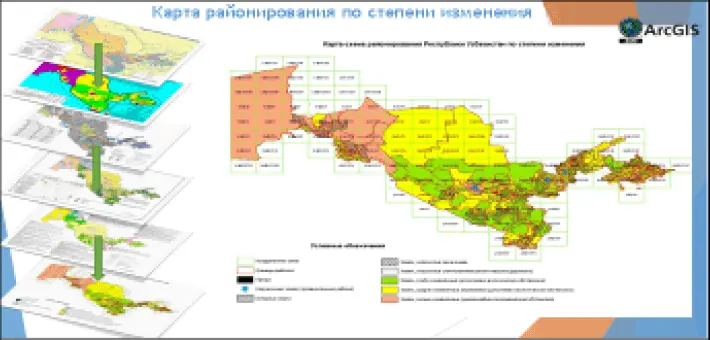
Methodological requirements for regional hydrogeological studies (1:200,000) have been developed in territories with changed natural and man-made conditions, the compilation of a new generation State hydrogeological map and the creation of a hydrogeochemical database of changes in groundwater quality based on GIS technologies
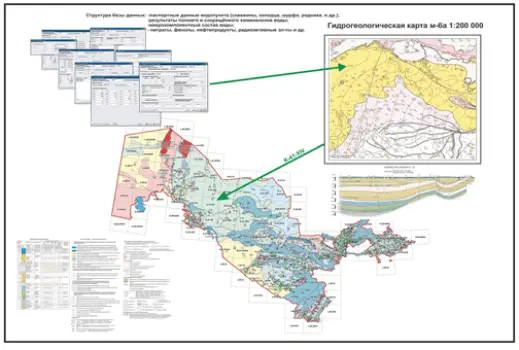
An automated hydrogeochemical data bank and data entry based on the results of the state hydrogeological survey m-ba 1:20000 have been developed. An automated information and analytical system has been created on a PC with a structure of formal logical combinations of requests and the issuance of information on requests. A system has been developed for searching and displaying the location of objects on the map based on attribute and spatial queries and the inverse problem – attribute characteristics of objects based on their location on the map using the GIS technology of the ArcGIS program. Linking the hydrochemical data bank to cartographic materials, improving access to information for predicting changes in water quality, combinations of requests and issuing information on interpreted boundaries for specific classes of PV mineralization. Providing information in a user-friendly form and bringing it to the consumer.
Digital map of hydrogeological content based on the results of complex hydrogeological and engineering-geological surveys at the scale of 1:200 00 and 1:50 000
An automated information and reference database using GIS technologies has been developed, which makes it possible to repeatedly speed up the search for the necessary material at the bibliographic, territorial and thematic level. Promptly and fully review the hydrogeological, engineering-geological and geoecological study of the territory. Its binding to the map gives the hydrogeologist a better idea of the subject under study. The created database allows integration with other databases, thereby expanding the possibilities of systematization of geological information on various aspects of hydrogeology, engineering-geology and geoecology, containing information on the chemical composition of groundwater, hydrogeological and engineering-geological parameters of aquifers and rocks of the aeration zone, lithological composition and stratigraphic age of the section, geophysical properties, etc.